Erosion catastrophe in Ecuador sparks ‘rare’ NGA drone mission
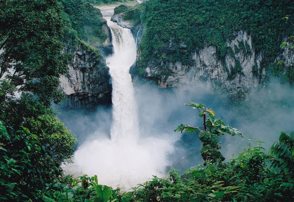
KISSIMMEE, Fla. — A sinkhole caused an upstream riverbed to collapse in 2020, subsequently destroying what was previously Ecuador’s largest and tallest waterfall, San Rafael Falls, which historically stood at about 430 feet. That chain of events led to an unusual mission for the National Geospatial-Intelligence Agency, dubbed Project Condor.
The waterfall ceased to exist by the end of 2021, and in 2023, U.S. Ambassador to Ecuador Michael Fitzpatrick contacted NGA leadership for help. Specifically, he asked for assistance capturing data and digitally mapping the impacted areas of intensely challenging terrain using drones.
“I think that was mighty rare. I have not heard of any other instances assigned to NGA where an ambassador literally reached to the director of NGA to ask for support because of an environmental disaster that’s going on,” U.S. Coast Guard Capt. John Boller told DefenseScoop on Tuesday.
Boller serves as operations chief in the NGA Data and Digital Innovation Directorate’s Warfighter Support Office. With more than three decades of experience across the intelligence community and law enforcement, at NGA he oversees the rapid delivery of geospatial intelligence (GEOINT) technology and capabilities to military personnel at the tactical edge.
During a presentation at the annual GEOINT Symposium this week and an interview with DefenseScoop on the sidelines of the conference, Boller shared new details about NGA’s mission support effort — Project Condor — which was led by the Warfighter Support Office and Oak Ridge National Laboratory, with support from the U.S. Embassy, Army Corps of Engineers, the Ecuadorian military’s geospatial division and electricity cooperation of Ecuador.
When the riverbed collapsed in 2020, the Coca River was diverted through a sinkhole below the waterfalls that eventually demolished the lava dam supporting them.
According to Boller, that regressive erosion upstream accompanied by excessive sedimentation downstream is now seriously threatening Ecuador’s oil pipelines, bridges, towns, roads and critical infrasturcture.
Also at risk is the future operational status of the China-built Coca Codo Sinclair Hydroelectric Dam that’s approximately 12 miles upstream from the point of collapse. The associated plant, Boller noted, supplies at least 25% of Ecuador’s power — and losing the electricity generated by this dam would be the equivalent to the U.S. losing power in every state west of the Great Plains.
“The erosion is a mess, and it’s starting to wipe out towns. The oil infrastructure is getting devastated right now. And the big takeaway is if the electric plant goes down,” he told DefenseScoop.
“We’re not exactly sure what’s going to happen to that country, because it’s already in chaos with some of the problems going on internally. And the last I heard is that Ecuador shuts down 13 hours a day for lack of power, so they can’t afford to lose the hydroelectric dam,” Boller added.
Without proper mitigation informed by high-resolution data models, the erosion could ultimately result in a humanitarian crisis.
Because the terrain of the surrounding Amazon rainforest basin presents austere conditions of unpredictable and extreme weather, high-altitude sensors were determined to be inadequate to collect imagery there.
So NGA brought in a cache of small drones.
Between Nov. 29 and Dec. 7, 2023, the agency’s QX team deployed small unmanned aerial systems on-site in Ecuador to collect more than 62 miles of unclassified, high-res, electro-optical, thermal and multispectral imagery of the river.
“The NGA team processed the raw data into multiple 2D and 3D products for the Army Corps of Engineers and the government of Ecuador, to assist in creating better engineering models to mitigate the erosion threatening the critical infrastructure,” Boller said during his presentation.
“The team’s speed, flexibility and ingenuity led to not only a successful mission, but also improved relations with our partners in Ecuador. The team over-delivered by providing more data than planned and less time and expense than projected,” he added.
Two officials who participated in this mission — Matt Larson, a research and development staff scientist in autonomous systems at Oak Ridge National Laboratory, and NGA’s principal systems engineer Michael Shellenberger, who is also a former Green Beret — accompanied Boller onstage for the presentation, where they shed light on the 39 flights their team conducted at 800 to 2,100 feet above terrain that presented a range of environmental challenges.
Beyond using visible, thermal, multispectral sensors, they said the Project Condor team deployed three UAS platforms: the Quantum Systems Trinity F90+, AgEagle eBee TAC and Skydio X2D.
“The guys that went into the field and went into the jungles — that was a big deal. I mean, that’s not a typical assignment for NGA,” Boller told DefenseScoop in the interview.
This leg of the collaborative effort concluded, he confirmed, but the overarching mission is still far from complete.
“There’s ideas being put forward. The Army Corps of Engineers, embassy and national electric company of Ecuador want to be able to remap it again. Will it be NGA doing that? I’m not exactly sure. I don’t determine that. I think a lot of that’s going to come back to, if it’s requested through the proper channels, then we can discuss and maybe put our guys back on it again,” he told DefenseScoop.